Spatial Analysis of the COVID-19 Pandemic in Hungary
Changing Epidemic Waves in Time and Space
DOI:
https://doi.org/10.18335/region.v8i2.343Abstract
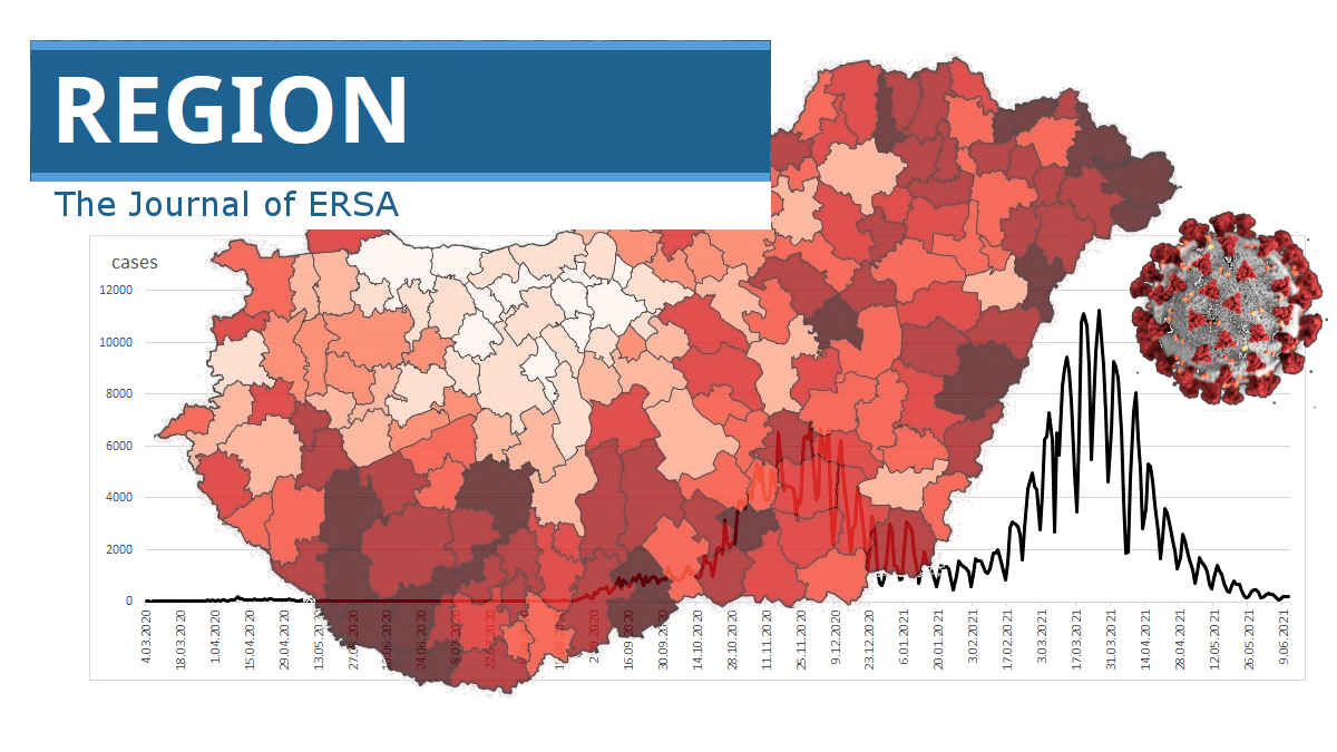
This paper examines the spatial dynamics and regional distribution of the novel coronavirus epidemic in Hungary in an effort to obtain a deeper understanding of the connection between space and health. The paper also presents comprehensive epidemiologic data on the spatiotemporal spread of the COVID-19 pandemic in terms of the epidemic waves. Following a comparison of the growth rates of infection numbers, the current study explores the geographical dimension of the three pandemic waves. The partial transformation of spatial characteristics during the three epidemic waves is among the most important results found. While geographical hotspots influenced the first wave, newly confirmed coronavirus cases in the second and third waves were due to community-based epidemic spreading. Furthermore, the western-eastern spatial relation and the core-periphery model also affected the regional distribution of new cases and deaths in the initial two waves. However, a new spatial pattern - realised by the northern-southern spatial orientation - appeared during the third wave. The outputs of this paper offer feasible suggestions for evidence-based policymaking in pandemic prevention, mitigation, and preparedness.
Downloads
Published
How to Cite
Issue
Section


License
Copyright (c) 2021 Annamaria Uzzoli, Sándor Zsolt Kovács, Attila Fábián, Balázs Páger, Tamás Szabó

This work is licensed under a Creative Commons Attribution-NonCommercial 4.0 International License.
REGION is an open journal, and uses the standard Creative Commons license: Copyright We want authors to retain the maximum control over their work consistent with the first goal. For this reason, authors who publish in REGION will release their articles under the Creative Commons Attribution license. This license allows anyone to copy and distribute the article provided that appropriate attribution is given to REGION and the authors. For details of the rights authors grant users of their work, see the "human-readable summary" of the license, with a link to the full license. (Note that "you" refers to a user, not an author, in the summary.) Upon submission, the authors agree that the following three items are true: 1) The manuscript named above: a) represents valid work and neither it nor any other that I have written with substantially similar content has been published before in any form except as a preprint, b) is not concurrently submitted to another publication, and c) does not infringe anyone’s copyright. The Author(s) holds ERSA, WU, REGION, and the Editors of REGION harmless against all copyright claims. d) I have, or a coauthor has, had sufficient access to the data to verify the manuscript’s scientific integrity. 2) If asked, I will provide or fully cooperate in providing the data on which the manuscript is based so the editors or their assignees can examine it (where possible) 3) For papers with more than one author, I as the submitter have the permission of the coauthors to submit this work, and all authors agree that the corresponding author will be the main correspondent with the editorial office, and review the edited manuscript and proof. If there is only one author, I will be the corresponding author and agree to handle these responsibilities.
